Drainage System
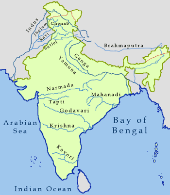 On the basis of the origin of the rivers, Indian river systems can be classified as:
1. Himalayan Rivers
2. Peninsular Rivers
Indian Rivers
HIMALAYAN RIVER SYSTEM
It comprises of the following 3 major river system:
1. The Indus river system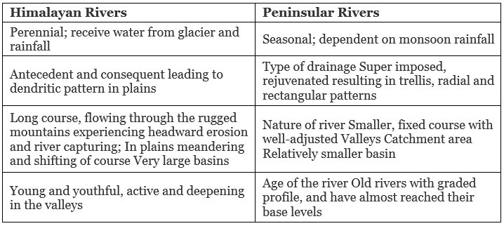
2. The Ganga river system
3. The Brahmaputra river system
1. The Indus river system
- It has a total length of 2880 km (1114 km in India).
- It originates from a glacier near Bokhar Chu in kailash Mountain range in Tibet region and finally falls into Arabian Sea near karachi.
- In tibet, it is known as “Singi khamban”
- In Jammu and Kashmir, its Himalayan tributaries are: Zanskar, Dras, Gartang, Shyok, Shigar, Nubra, Gilgit, etc.
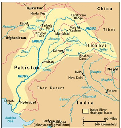
Its most important tributaries, which join Indus at various places, are:
- Jhelum (725 km),
- Chenab (1800 km),
- Ravi (720 km),
- Beas (470 km) &
- Sutlej (1050 km).
These rivers join Indus at Mithankot.
2. The Ganga river system
- It is 2525 km long; of which 110 km flows in Uttarakhand, 1450 km in UP, 445 km in Bihar and 520 km in West Bengal.
- The Ganga is constituted of two main rivers – Bhagirthi and Alaknanda, which combine at Devprayag to form Ganga.
- Before Alaknanda meets Bhagirthi at Devprayag, Mandakini meets Alaknanda at Rudraprayag.

Sources: Bhagirthi from Gaumukh, Alaknanda from Badrinath, Mandakini from Kedarnath (all from Uttarakhand).
- The river finally falls into Bay of Bengal near the Sagar Island.
- Yamuna is the important tributary of Ganga
Apart from Yamuna, other tributaries of Ganga are:
- Ghaghra (1080 km),
- Son (780 km),
- Gandak (425 km),
- Kosi (730 km),
- Gomti (805 km),
- Damodar (541 km).
- Kosi is infamous as ‘Sorrow of Bihar’, while Damodar gets the name ‘Sorrow of Bengal’ as these cause floods in these regions.
- Hooghli is a distributary of Ganga flowing through Kolkata.
- Yamuna (1375 km) is its most important tributary (on right bank).
- It rises at the Yamunotri glacier in Uttarakhand.
- It runs parallel to Ganga for 800km and joins it at Allahabad.
Important tributaries of Yamuna are:
- Chambal (1050 km),
- Sind,
- Betwa (480 km) and Ken
Ghaghra (1080 km)
- Originates from the glacier of Mapchachungo
- It is joined by kali river
- It meets Ganga at Chhapra
Gandak (425 km)
- Rises in Nepal Himalayas
- Enters the Ganga plain in Champaran
- Joins Ganga at Sonpur near Patna
Kosi (730 km)
- Its source is to the north of Mount Everest in Tibet
Ramganga
- Rise in Garhwal hills
- Joins Ganga near kannauj
Damodar (541 km)
- Rises in Chhotanagpur plateau
- Flows in a rift valley & finally joins river Hugli
Chambal
- A tributary of Yamuna
- Rises near Mhow in Malwa plateau, M.P
- Famous for its badland topography
Son (780 km)
- A tributary of Ganga
- Originates from Amarkantak plateau
- Joins Ganga near Patna
3. The Brahmaputra River system
- It has a total length of 2900 km.
- It rises in Tibet (from Chemayungdung glacier) near Mansarovar lake, where it is called Tsangpo,
- It enters the Indian territory (in Arunachal Pradesh) under the name Dihang.
- Its important tributaries are: Subansiri, Kameng, Dhansiri, Manas, Teesta.
- In Bangladesh, Brahmaputra is known by the name of Jamuna while Ganga gets the name Padma.
- Their combined stream is known as Padma only.
- Meghna is the most important distributory before it enters the Bay of Bengal.
- The combined stream of Ganga and Brahmaputra forms the biggest delta in the world, the Sundarbans (58,752 sq. km).
- On Brahmaputra is the river island, Majuli in Assam, the biggest river island in the world.
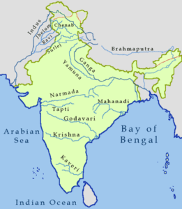
PENINSULAR RIVERS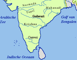
Mahanadi River (858 km)
- Rises in Raipur distt. in Chhatisgarh.
- Main tributaries: lb, Seonath, Hasdo, Mand, Jonk, Tel, etc.
Godavari River (1465 km)
- Also called Vriddha Ganga or Dakshina Ganga.
- It is the longest peninsular river.
- Rises in Nasik.
- Main tributaries: Manjra, Penganga, Wardha, Indravati, Wainganga, Sabari, etc.
Krishana river
- Rises in Western Ghats near Mahabaleshwar.
- Main tributaries: Koyna, Dudhganga, Panchganga, Malprabha, Ghatprabha, Bhima, Tungabhadra, Musi, etc.
Swarnarekha River (395 km) and Brahmani (705 km)
Rises from Ranchi Plateau.
Cauvery River (805 km)
- It is the largest peninsular river (maximum amount of water).
- Infact, it is the only peninsular river which flows almost throughout the year.
- Known as the ‘Ganga of the South’.
- It rises from the Brahmagir range of Western Ghats.
- Main tributaries: Hemavati, Lokpawni, Shimsa.
Narmada River (1057 km)
- Rises in Amarkantak Plateau and flows into Gulf of Khambat.
- It flows in a rift valley between Vindhya & Satpura.
- It forms the famous Dhuan Dhar Falls near Jabalpur.
- Main tributaries: Hiran, Burhner, Banjar, Shar, Shakkar, Tawa, etc.
Tapti River (724 km)
- Rises from Betul distt in MP
- Main tributaries: Purna, Betul, Arunavati, Ganjal, etc.
Mahi River (560 km)
- Rises from Vindhyas in MP
Luni River (450 km)
- Rises from Aravailis.
- It is finally lost in the marshy grounds at the head of the Rann of Kuchchh.
Shravati
- Sharavati is a west flowing river of the Sahyadris.
- It forms the famous Jog or Gersoppa or Mahatma Gandhi Falls (289 m), which is the highest waterfall in India.
HIMALAYAN RIVERS
- The Himalayan rivers belong to the three principal systems — The Indus, The Ganga, and the Brahmaputra.
- The Indus rises in Tibet at an altitude of 5,180 m near the Mansarover lake. It flows west the north-westwards and enters Indian territory in Jammu and Kashmir.
The Himalayan rivers 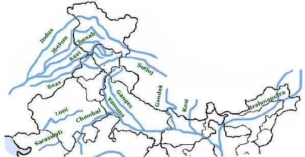 The river forming a spectacular gorge in this reach pierces the Kailash range several times. The Indus receives its Himalayan tributaries in J&K.
- The collective flow of its well known Punjab tributaries Sutlej, Beas, Ravi, Chenab, and Jhelum goes to make the Panjnad which falls into Mainstream a little above Mithankot.
- The Indus flows south-westwards across Pakistan to reach the Arbain sea, east of Karachi.
- The Ganga rises in the Uttar Pradesh Himalayas. The river acquires its name after its headstreams Alaknanda and Bhagirathi unite at Devaparyag.
- Flowing west south-westwards the Ganga declutches from the hills near Hardwar.
- The main right bank tributaries of the Ganga in the region of the plain include the Yamuna and the Son, besides the minor streams of the Tons and the Punpun.
- On its left bank the Ganga, however, receives a large number of tributaries, including the Ramganga, Gomati, Ghaghra, Gandak, Kosi, and Mahananda. Beyond Farakka, the mainstream of the Ganga flows east-south eastwards into Bangladesh and is known as Padma.
- Before falling into the Bay of Bengal below Chandpur in Bangladesh, the Padma receives the Brahmaputra known here as the Jamuna and the Meghna.
PENINSULAR RIVERS
- The broad, largely graded and shallow valleys of the peninsular rivers indicate that they have existed for a much longer period of time than the Himalayan rivers. With the exception of the limited reaches of some of the rivers where recent faulting has occurred, the beds have a subdued gradient. The erosional forces are now acting by and large laterally.
 The Peninsular rivers
 - The main water-shed in the Peninsular region is formed by the Western Ghats.
- Major rivers of the Peninsula such as the Mahanadi, Godavari, Krishna, and Cauvery flow eastwards on the Plateau and drain into the Bay of Bengal. These rivers have huge deltas near their mouths.
- Notable exceptions are, however, seen in the Narmada and the Tapi, which flow in a direction opposed to this general trend (they drain into Arabian sea) in troughs which have been formed due to faulting.
- These facts can be explained by supposing that the Western Ghats represents an original water-shed. However, the subsidence of the western flank of the Peninsular block has led to its submergence below the sea and had disturbed the generally symmetrical plan of the rivers on either side of the original water-shed.
- A second major distortion was introduced by the upheaval of the Himalayas due to which the northern flank of the Peninsular block was subjected to subsidence and the consequent trough-fault in.
- The Narmada and the Tapi flow in such trough-faults and have courses consequent to their general trend.
- In the process of alluvial activity they seem to have filled the original cracks with their detritus. This largely explains the lack of alluvial and deltaic deposits in their valleys.
DIFFERENCES BETWEEN HIMALAYAN AND PENINSULAR RIVERS
There are significant differences in the drainage features and hydrological characteristics between the Himalayan and the Peninsular systems of rivers. They are:-
- The Himalayan rivers are still actively shaping their valley and adjusting their course due to the youthful topography of the Himalayas. These are called antecedent rivers; their courses are older than the mountain ranges. Since the mountain range got uplifted, the rivers have maintained their paths by butting deep gorges, for example, the Indus, the Sutlej and the Brahmaputra.
The Peninsular rivers have a senile (old) topography. Here the rivers have adjusted with the topography. These rivers flow through broad valley and gentle slopes. - The Himalayan rivers have no evidence of superimposed and rejuvenated topography. Consequently, the rivers make waterfalls only at those points where structural differences exist.
Peninsular rivers have several evidences of rejuvenation and superimposed topography. It leads to superimposed drainage and resurrection on the courses of the Godavari, the Krishna, the Cauvery etc. - The well developed dendritic pattern of drainage (a very good network like a tree) is found in the Himalayan system. The river system of the Great Plain are free to develop their course in alluvial sediments.
The Peninsular rivers follow the major trend lines and joints in the crystalline rocks. Their course do not shift except in a few cases in the lower reaches. Peninsular rivers are obstructed by dykes and quartz veins. - The Himalayan rivers are longer and perennial; fed by the melting snow and monsoonal rainfall.
The Peninsular rivers are shorter and rain fed and thus seasonal in nature. While the small rivers are non-perennial the larger rivers have low discharge during summers. - The Himalayan rivers have large command areas.
The Peninsular rivers have the smaller command areas . - The Himalayan rivers are better suited for irrigation as they are perennial and canals can be easily dug on the alluvial low lands.
The Peninsular rivers are better placed in terms of hydro electric power development as the west flowing rivers have a large volume of the water and flow over the steep of the Sahyadris. - The Himalayan rivers carry on large erosion.
The Peninsular rivers carry little erosion.
DRAINAGE SYSTEM OF PENINSULAR INDIA
Most of the Peninsular rivers are seasonal. These flow through narrow, deep, valleys.
These rivers can be divided into two categories:
(i) Rivers falling into the Arabian Sea.
(ii) Rivers falling into the Bay of Bengal.
(i) Rivers falling into the Arabian Sea
- The Narmada — It rises from Amarkautak Plateau in Madhya Pradesh. It is 300 km long. It flows through a rift valley between the Vindhyas and Satpuras. Kapildhara falls are important. It does not form a delta on the western coast.
- The Tapti — It rises near Betul in Mahadeo Hills. It is 724 km long. It flows through a rift valley. Looni, Sabarmati, and Mahe are other main givers falling into the Arabian Sea.
(ii) The rivers falling into the Bay of Bengal
- Damodar River—The Damodar, 530 km long, rises from Chotta Nagpur plateau, on account of its floods, it is called River of Sorrow.’. D.V.C. Project is a multipurpose project to get benefits from this river.
- The Mahanadi—It is 857 km long. It emerges from Amarkantak Plateau. It is a navigable river and forms a fertile delta.
- The Godawari—It is 1440 km long and rises from the Western Ghats. It is the longest river of the Peninsula. It forms a fertile delta on the East Coast.
- The Krishna—It is 1400 km long. It rises near Mahabaleshwar in Western Ghats. Its tributaries—Bhima and Tungbhadra are important.
- The Cauvery—It rises in Brahmgiri in the Coorg district. It is 800 km long. It is useful for irrigation, navigation and water power development. The famous Shivasmudarm falls lie on this river. It forms a fertile delta on the East Coast.
- Dakshina Ganga or Virdha Ganga
The Godavari is the longest of the Peninsular rivers. It has an extensive drainage basin covering 312, 812 sq. kms. Its drainage basin extends through Maharashtra. Madhya Pradesh, Karnataka, Orissa and Andhra Pradesh. Because of its large size and extent, it is compared to river Ganga. It has got the same cultural significance in the peninsular Indian as the Ganges has in the northern plain. Therefore it is referred as Dakshina Ganga or Vridha Ganga. The Ganga river has got a large number of tributaries. The Godavari has also got many tributaries.
SUB-CONTINENT
A Sub-Continent is a vast independent geographical unit. This land mass is distinctly separated from the main continent. The vastness in size produces a diversity in economic, social and cultural conditions. India is a vast country. It is often described as ‘Indian sub-continent’.
The Himalayan mountain system acts as a physical barrier separating the Indian sub-continent from the main land of Asia. India, Pakistan, Bangladesh, Nepal and Bhutan, combine together to form a sub-continent. The great mountain wall isolates these countries from Asia.
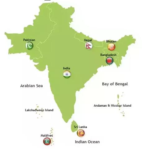 The Indian sub-continents
India can be said to occupy the most central position in the Indian Ocean:
(i) India lies at the head of the Indian Ocean. The Indian Ocean extends between 0°E to 120°E longitudes, with Kanyakumari located along 80°E longitude. Thus India occupies a central position in the Indian Ocean.
(ii) The Deccan peninsula projects itself in the centre of Indian Ocean, between Arabian Sea and Bay of Bengal.
 Central position of India in the Indian ocean
(iii) No other country has such a large coastline along the Indian Ocean. That is why it is named after the country of India.
(iv) India lies on the trade routes of Europe and the far east passing through the Indian Ocean.
(v) India occupies a centrally located strategic position in the eastern hemisphere. India is by far the most dominant country surrounding the Indian Ocean.
Characteristics of Western Ghats
The Western Ghats with an average height of 1200 meters run parallel to the west coast for 1600 km from Kanyakumari to the River Tapti. Its highest peaks are more than 1500 m.
The range rises almost perpendicularly from the narrow coastal plains. The land-scape is composed of step sided valley, narrow gorges and water falls of great magnitude.
Physiography of the islands that form part of the territory of India
There are large number of islands which form part of the territory of India. Most of them are situated in the Bay of Bengal and a few in the Arabian sea and the Gulf of Mannar.
- The major group of islands in the Bay of Bengal are the Andaman and Nicobar islands which lie in a north-east to south-easterly direction between 10° and 14°N latitudes. They are grouped into the North, Middle and South Andamans. They are mostly formed of tertiary sandstone, limestone and shale rise to a height of 730 metres. The islands are separated by narrow mangrove fringed inlets and surrounded by coral reef. The Nicobar group numbering 19 islands to the south of the Andamans consist of the Great Nicobar, Little Nicobar, Katchall Camorts and other islands.
- Islands situated in the Arabian Sea are coral of reef origin.
Geomorphological features of the Himalayas with those of the Indian plateau
(i) The Himalayas
1. The Himalayas are young new fold mountains
2. These mountains have been formed due to folding by different earth movements.
3. The relief features show the young age of the Himalayas.
4. Parallel mountain ranges are formed in the Himalayan region.
5. These mountains are the loftiest mountain system of the world with the highest mountain peak Mt. Everest 8848 meters. above sea level.
6. These mountains extend in an arc.
7. Deep gorges and U-shaped valleys are formed.
8. These have been formed out of Tethys Sea in the Mesozoic period (276 Million years ago)
9. It is made up of sedimentary rocks.
(ii) Indian Plateau
1. The Indian plateau is an ancient crystalline tableland.
2. This plateau has been formed as a horst.
3. The plateau is old and well dissected.
4. Rift valleys are formed due to faulting
5. It is an old eroded crystal rock with the highest peak Anaimudi 2695 mts. above sea level.
6. This plateau is triangular in shape.
7. Narrow deep river valleys are formed on the plateau.
8. This plateau has been lifted out of the sea in the Precambrian period (1600 million years ago).
9. It is made up of Igneous rocks.
DRAINAGE SYSTEM OF NORTHERN INDIA
Most of the rivers of Northern India originate from the Himalayas. These are perennial rivers as these are snow-fed rivers. Many rivers belong to the antecedent drainage system.
 Drainage system of India
The northern plain has been formed by the deposition of sediments brought down by these rivers.
This drainage system extends from Punjab to Assam and is divided into three systems:
(i) The Indus system
(ii) The Ganges system
(iii) The Brahmaputra system
1. The Indus Drainage System
It is one of the world’s largest systems. It comprises the rivers of the Indus, the Jhelum, and the Chenab, flow in Pakistan.
(i) The Sutlej: It originates from Rakshas Tal near Mansarovar lake across the Himalayas. It forms a deep gorge. It is 1448 km long and feeds the Bhakra canal.
(ii) The Beas: It originates from the Beas Kund near Rohtang pass. It is 460 km long. It lies within the boundaries of Punjab state.
(iii) The Ravi: The Ravi rises in Dhauladhar Hills. It enters the plains near Madhopur. It is 720 km long and forms a natural divide between India and Pakistan.
2. The Ganges Drainage System
(i) The Ganges - The Ganges is the most sacred river of India. The story of the Ganges from her source to the sea, from old times to new is the story of India’s civilisation and culture. The Ganges has its source near Gomukh glacier, near Gangotri. The Ganges is formed by two headstreams namely Alaknanda and Bhagirathi. It enters the plains near Hardwar. The Yamuna meets this river at Allahabad known as Sangam. The Ganges is the master stream of the area. South of Farakka, the river divides into a number of Channels to form ‘Sunder Ban’ Delta. The Ramganga, Ghaghra, Gandak, Baghmari join the Ganges from its left. The Yamuna and the Sone join it from the South. It is 2522 km long. Hardwar, Kanpur, Allahabad, Varanasi, Patna, and Culcutta are situated along the Ganga.
(ii) The Yamuna - It is the most important tributary of the Ganga. It is 1375 km long. It rises from the Yamnotri Glacier. The Chambal, Betwa, and Ken rivers join the Yamuna from the South.
(iii) The Kosi - The Kosi emerges from the great Himalayas. It flows for 730 km in Nepal and India. It is known for its notorious floods and called “River of Sorrow”
3. The Brahmaputra System
The Brahmaputra river is the master stream of this system. It is 2880 km. long. It flows parallel to the Himalayas in Tibet and is known as Tsangpo, it enters India in Arunachal Pradesh through Dihang gorge. It is known for its notorious floods and silt deposits. It joins the Padma river in Bangladesh to form a large delta.
Comments
Post a Comment