Physiography of India (Part - 2)
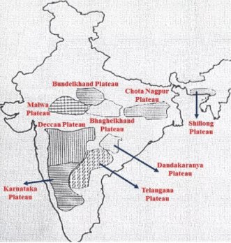
Deccan Plateau has the following features:
- The Deccan Lava Plateau Region
- Telangana Plateau
- The Karnataka Plateau
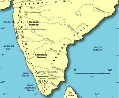
The Deccan Lava Plateau Region - The northwestern part of Deccan Plateau is the region of basaltic lava.
- It includes the Western Ghats north of 160N latitude, plateau of Maharashtra (except the east of Nagpur) and the adjoining parts of Madhya Pradesh, Karnataka and Andhra Pradesh.
Telangana Plateau - Part of the Deccan Plateau comprises of the interior region of Andhra Pradesh.
- North of Krishna River is the plateau of Telangana.
- South of the Krishna River, lying in the Rayalseema plateau region.
The Karnataka Plateau - Situated to the south of Deccan Lava Region.
- Malnad and Maidan are two physiographic regions of Karnataka Plateau.
(i) Malnad
- Hilly and dissected plateau region about 35 km wide lying close to the Western Ghats. The highest hills is the Bababudan group.
(ii) Maidan
- Situated in the eastern part of Malnad, relatively large rolling plains with low granitic hills.
Plateau
- It is an extension of main peninsular plateau
- It includes Meghalaya and karbi-Anglong plateau
- Meghalaya plateau is further sub-divided into Garo hill, khasi hill & Jaintia hills
- this plateau is highly eroded because it is high rainfall area
Coastal Plains
- This is a narrow belt and provides natural conditions for the development of the ports & the harbours.
- From Gujarat to Kerala they can be divided into kutch & Kathiawar coast, Konkan coast and Malabar coast
 Coastal plains
On the basis of location, the plains can be divided into :
- The western coastal plains
- The eastern coastal plains
KATHIAWAR COAST
- Extends from Rann of Kutch to Daman in the south
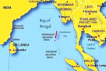
THE ISLANDS
There are two major groups of the island in India - Bay of Bengal group
- Arabian Sea group
Bay of Bengal
- This group consists of 572 islands
- The group is divided into Andaman in the north & Nicobar group in the south
- They are separated by “ten degree channel”
 Bay of Bengal islands
 - These are believed to be the extension of Arakan Yoma mountain
- Barren island, the only active volcano is situated in the Nicobar island
- The Pamban Island, situated between India and Sri Lanka, has a rocky surface, is an extension of the peninsular surface in Ramnad district of Tamil Nadu.
Arabian sea islands - This group include the Lakshadweep and Minicoy islands
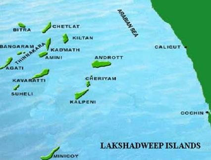
- There are approx. 36 islands
- These are built of coral deposits
Arabian sea islands - Minicoy is the largest island
- The group is divided by 11 degree channel, north of which is the Amini island and to the south is the Cannanore island
Comments
Post a Comment