
UPSC Geography : Class 1 : India Introduction


Introduction To Indian Geography

India: Location And Size

Location

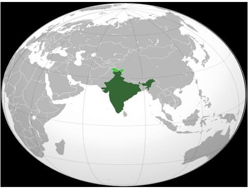
  • India is a vast country. Lying entirely in the Northern hemisphere, the main land extends between latitudes 8°4’N and 37°6’N and longitudes 68°7’E and 97°25’E.
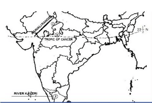
  • The Tropic of Cancer (23° 30’N) divides the country into almost two equal parts.
  • To the southeast and southwest of the mainland, lie the Andaman and Nicobar islands and the Lakshadweep islands in Bay of Bengal and Arabian Sea respectively.

Size

  • Geography Area of India : 32,87,263 sq. km.
  • It accounts for 2.4% of the total world area and roughly 16% of the world population.
  • India is the seventh largest country of the world.
  • India has a land boundary of about 15,200 km and the total length of the coast line of the mainland including Andaman and Nicobar and Lakshadweep is 7,516.6 km.

India’s Neighbours

  • India occupies an important strategic position in South Asia.
  • India shares its land boundaries with Pakistan and Afghanistan in the northwest China , Nepal and Bhutan in the north and Myanmar and Bangladesh in the east.
  • Our southern neighbours across the sea consist of the two island countries, namely Sri Lanka and Maldives.
  • Sri Lanka is separated from India by a narrow channel of sea formed by the Palk Strait and the Gulf of Mannar while Maldives Islands are situated to the south of the Lakshadweep Islands.

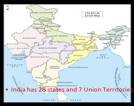
Facts about position of states

UP borders the maximum number of States-8 (Uttarakhand, HP, Haryana, Rajasthan, MP, Chhattisgarh, Jharkhand, Bihar). After UP is Assam, which touches the border of 7 States

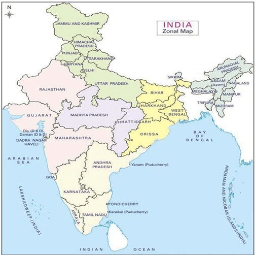
Tropic of Cancer passes through 8 States : Gujarat, Rajasthan, MP, Chhattisgarh, Jharkhand, WB, Tripuro, Mizoram

  • Indian Standard Meridian passes through 5 States : UP, MP, Chhattisgarh, Orissa, AP.

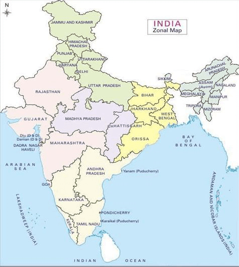
  • 9 States form the coast of India. They are : Gujarat, Maharashtra, Goa, Karnataka, Kerala, Tamil Nadu. Andhra Pradesh, Orissa and West Bengal.
  • 2 Union Territories, viz. Daman & Diu and Pondicherry are also on the coast.
  • The Union Territories of Andaman and Nicobar Islands and Lakshadweep are made up of islands only.

Comments

Popular posts from this blog

Laxmikanth Polity Summary Chapter 1

  Table Of Contents Historical Development of constitution of India Timeline of British rule in India Important Acts Passed during British India and their Provinces Rule in India (1773-1858) Rule in India (1858-1947) Historical Development of Constitution of India During 200 years of British rule in India various acts were passed in order to have a better control over the administration of this diversified large land under both Company and the Crown rules. These acts have a great influence on country’s present political structure and various constitutional provisions. Timeline of British Rule in India 1. The Company Rule(1773-1857): 2. The Crown Rule (1858-1947) Question: When did the "Crown/Queen Rule" started in India?  a. 1833 b. 1858 c. 1919 d. 1773 ➢  Important Acts passed during British India and their Provisions: 1.  Rule in India (1773-1858) (i)  Regulating Act, 1773 Features of the Act: The act was the first attempt to regularize company affairs in Indi...

Climate

  CLIMATIC DIVERSITY FACTORS AFFECTING INDIAN CLIMATE LATITUDE   THE HIMALAYAS  WEATHER MECHANISMS The variations in local climates of India arise due to a number of factors including : (i) Surface distribution of pressure and winds, (ii) Upper air circulation caused by factors controlling global weather and the inflow of different air masses and jet streams and (iii) Inflow of western disturbances during the winter months and the tropical depressions during the South-West monsoon period into India creating weather phenomena conditions for rainfall. Pressure and surface winds These mechanisms can be described with reference to the two main seasons of the year i.e,  winter  and  summer  when striking changes in weather occur.  The distribution pattern of pressure in Central and West Asia generally influences the weather conditions of India during the winter months. A high pressure centre in the region lying to the north of the Himalaya gives rise t...

India Drainage System

  Drainage System On the basis of the origin of the rivers, Indian river systems can be classified as: 1.  Himalayan Rivers 2.  Peninsular Rivers Indian Rivers HIMALAYAN RIVER SYSTEM It comprises of the following 3 major river system: 1. The Indus river system 2. The Ganga river system 3. The Brahmaputra river system 1. The Indus river system It has a total length of 2880 km (1114 km in India). It originates from a glacier near Bokhar Chu in kailash Mountain range in Tibet region and finally falls into Arabian Sea near karachi. In tibet, it is known as “Singi khamban” In Jammu and Kashmir, its Himalayan tributaries are: Zanskar, Dras, Gartang, Shyok, Shigar, Nubra, Gilgit, etc. Its most important tributaries, which join Indus at various places, are: Jhelum (725 km), Chenab (1800 km), Ravi (720 km), Beas (470 km) & Sutlej (1050 km). These rivers join Indus at Mithankot. 2. The Ganga river system It is 2525 km long; of which 110 km flows in Uttarakhand, 1450 km in UP, 4...