THE COASTAL PLAIN AND ISLANDS
The Coastal Plains
- The peninsular plateau is bounded by coastal plains on the east and west. There is wide difference between the eastern and the western coastal plains.
 The coastal plain
- The west coast is narrower but more wet than the east coast, which is much wider but relatively dry.
- A number of river deltas occur on the east coast, viz., the Mahanadi, the Godavari, the Krishna and the Cauvery, because the slope of Eastern Ghats is gentle and it allows rivers to form deltas and hence the east coast is broad whereas the steep slopes of Western Ghats (Sahyadris) do not allow such depositional action along the west coast and hence the west coast is narrower.
- The deltas of east coast form the ‘granary’ of the five southern states—Andhra Pradesh, Tamil Nadu, Karnataka, Kerala and Pondicherry.
- The western coastal strips which have a large number of lagoons and backwaters, on the other hand, are noted for spices, areca nuts, coconut, palms, etc.
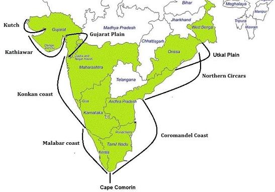
Western Coastal Plains
- These lie between the Western Ghats and the Arabian sea and stretch from Kutch in the north to Kanyakumari in the south.
- Kutch and Kathiawar peninsula and the Gujarat plain lie at their northern end.
- The Gujarat Plain is a broad and flat plain, occupied almost wholly by the state of Gujarat.
- The Kutch Peninsula also consists of a very low and rifle land.
- The two important inlets here are the Gulf of Kutch and the Gulf of Cambay. Narmada, Sabarmati, Tapti and Mahi drain this area into the Gulf of Cambay.
- The Kathiawar Peninsula, also known as Saurashtra, which lies to the south of Kutch, is also a plain level area except for some hills rising into Mount Girnar (1,117m).
- The coastal area is covered with windblown sand, but further south it is mostly alluvium brought by streams from the Western Ghats.
- Further south of the Daman, lie the western coastal plains proper which could be sub-divided regionally into the Konkan coast in Maharashtra Canara coast in Karnataka and Malabar coast in Kerala.
- Except the Gujarat plain and the Kathiawar peninsula, the Western coast has a narrow alluvial margin interspersed by hilly terrain.
- The coastal region here is not very broad. The Malabar coast is broader and less hilly.
- All along the coast are numerous streams, all short and with limited catchment areas.
- There are a number of lagoons, backwaters (Kayal) and small lakes, the largest of which is the Venchanar, about 60 km in length.
Eastern Coastal Plains - The coastal low lands extend from the mouth of the Ganga to Kanyakumari. The northern half is called northern Circars or Kalinga coast, while the southern half is known as the Coromandal coast.
- The east coast is broader than the west coast in several places. The broader part is the Carnatic region, which is about 480 km wide.
- It is also less rocky, but the sea around the coast is shallow, and ocean-going ships cannot come near.
- The surf is considered dangerous to land in small boats.
- All along this coast, the east flowing rivers have created large deltas as they bring vast quantities of alluvium.
- The prominent deltas are those of the Mahanadi, Godavari, Krishna and Cauvery. They are not suitable for harbours as their mouths being full of silt.
- There are several lakes on the east coast, the larger among them are Chilka in Orissa and Kollenu and Codicut in Andhra Pradesh.
Facts To Be Remembered |
|
Significance of Coastal Plans.
(i) Harbours: The coasts of India are very little indicted by larger inlets, the only significant ones being the Gulf of Cambay and the Rann of Kutch. The west coast has small inlets and east has delta creeks. Hence, natural harbours along the coasts are few. Bombay, Mamugao, Cochin, New Mangalore and Vishakhapatnam have natural harbours, but others do not. Hence, the facility of good port along the coastline.
(ii) Specialise Crops: The coastal plains are associated with specialised crops of spices, pepper, ginger and cardamom on the west coast and rice, areca nut palms and coconuts on the east.
(iii) Fisheries and Navigation: A large number of fishing villages abound near the coasts. The backwaters and lagoons on the coasts are linked together for navigation along the coast and the interior. Large catches of sardines, eel, anchovies, carp, silver fish, mullets marginal, etc. are caught near the coast.
(iv) Economic Influence: The coastline has a large number of scenic spots and beaches that provide recreation to a large number of tourists. Besides, salt is manufactured along the west coast throughout the year except the rainy season.
(v) Historical Importance: Ancient forts and factories are found scattered along the coastline. The east coast is studded with fertile gardens, with magnificent temples (such as a Madurai, Thanjavur and Kancheepuram) and decorative Hindu monuments )as at Mahabalipuram( with scores of ancient centre of culture and industry.
Facts To Be Remembered |
|
The present day geomorphological divisions of the sub-continent have evolved in the course of a long geological history
Indian Sub-continent is divided into three physiographic regions at macro level. These have been evolved in the course of a long geological history. The present day topography is the result of interaction of different courses over a long period.
1. The Plateau: The peninsular plateau is an old crystal block lifted in the pre-cambrian (1600 million years ago). It has been compared to a horst lifted above sea level. It has been a part of the super continent Gondwana land. Many structural changes occurred in the evolution of the plateau. Such as:
(i) Aravalli mountains were uplifted in Palaeozoic times.
(ii) Nallamalai range of the south was folded during the same period i.e. Vindhyan period. The Plateau(iii) Faulting along with vertical movements occurred in the river valleys of Godavari, Mahanadi, Narmada and Tapti.
(iv) Along with faulting, subsidence took place along the Malabar Coast.
(v) After that, extensive lava flow resulted in the formation of Deccan plateau.
(vi) Arabian sea was formed due to subsidence along the west coast.
(vii) Similarly western parts were formed as a result of the tilting of the peninsular plateau.
2. The Himalayas: The Himalayas are young fold mountain system. This region was occupied by the Tethys geosyncline as late as Mesozoic times (270 million years back). The sediments deposited in the Tethys sea were folded to form the Himalayas during the tertiary period. The Himalayas and its mountain ranges were gradually uplifted spreading over millions of years. The Himalayas were uplifted in three stages; —Central Himalayas, Potwar region and the Siwalik ranges. The mountain building movements occurred in different stages. The first uplift was marked during Oligocene period. The second phase to place in the post-Pliocene period. It has been observed that the Himalayas are still rising. Most of the present relief is the result of weathering and erosion by different agents. The Himalaya3. The Plains: The great plains of India lie in between the Himalayas and the plateau. It has been formed by filling of a marine depression by sediments brought down by the Himalayan rivers. This depression is derived to exit as a ‘foredeep’ formed by the subsidence of the northern flank of the plateau. The depression has been filled gradually. Rajmahal and Garo hills have been regarded as the boundaries of this depression and this gap has been filled by the Ganges alluvium in Bengal.
Major physiographic divisions and main characteristic of the northern mountain region
India is a vast country where severe contrasts are found in relief. The total geographical area is divided into different parts as:—
Mountains 10.7%
Hills 18.6%
Plateaus 27.7%
Plains 43.0%
- India is divided into four major physiographic divisions. The Peninsular India is the core of the geology of India. It is the oldest part of India. In the Northern part, the Himalayas adorn like a crown of India. The Gangetic plain is the cradle of Indian Civilisation. The four independent and definite physiographic regions are:—
1. The Northern Mountain Region.
2. The Sutlej-Ganga Plain
3. The Peninsular plateau
4. The coastal plain and islands
The Northern Mountain Region
The Himalayas run in an east-west direction in the northern part of India. This mountain range is 2400 km long and 240 to 320 km wide. These are the youngest and the highest fold mountains of the world.
Main characteristics
(i) These are young fold mountains.
(ii) These have been formed in tertiary period (5 crore years ago).
(iii) These were formed at the site of Tethys Sea. The sediments were uplifted to form high mountains. The Himalayas are still rising in some parts.
(iv) The Himalayas are a series of parallel ranges intersected by deep valleys and broad plateaus.
(v) These ranges are compared to a sword or a bow.
(vi) The average height of the Himalayas is 5000 metres.
(vii) Youthful rivers form narrow, deep valleys and gorges across the Himalayas.
(viii) The Himalayas show evidence of glaciation such as Karewas in Kashmir valley.
Division. The Himalayas, from Indus valley to Arunachal Pradesh, can be divided into four division:—
(i) Assam Himalayas— Between the Tista and Brahmputra river.
(ii) Nepal Himalayas—Between Kali and Tista rivers.
(iii) Kumaon Himalayas—Between Sutlej and Kali river.
(iv) Kashmir Himalayas—Between Indus and Sutlej river.
- From the point of height, the Himalayas can be divided into four ranges which run parallel to each other.
(i) Trans Himalayas
(ii) Great Himalayas—Av. height 6000 metres
(iii) Lesser Himalayas—Av. height between 3000 — 4500 metres
(iv) Siwaliks.—Av. height 1000 metres
Main characteristic of the Sutlej Ganga Plain
The great plain extends in between the Himalayas and the Peninsular plateau. It is 3200 km long and 150 to 300 km wide. Its average height is 150 metres. It covers an area of 7.5 lakh sq km.
- It is an alluvium filled trough. It has been formed by the deposition of sediments brought from the Himalayas by the Ganga, Sutlej, and other rivers
Main Characteristics:—
(i) It is a dead flat lowland. The maximum height is 283 metres near Ambala.
(ii) It has a gentle gradient (¼ metre per km).
(iii) It has huge depth of alluvium.
(iv) A large number of rivers flow in this plain dividing it into Doabs.
(v) It has fertile alluvial soils namely Khadar and Bangar soils.
Division of Northern Plain
(i) Bhabar and Terai
(ii) Punjab plains
(iii) Ganga plains
- Upper Ganga Plain
- Middle Ganga plain
- Lower Ganga plain
(iv) Brahmaputra plains
Main characteristics of the Peninsular Plateau
The Deccan Plateau is the oldest plateau of India. It is surrounded by oceans on three sides. Therefore it is often called Peninsular plateau . It covers an area of about 16 lakh sq km. The average altitude of the plateau varies from 600 to 900 metres. Its limits are formed by the Aravallis in the North. Rajmahal Hills and Shillong plateau in the East. The Southern most point is known as Kanyakumari.
Characteristics:: (i) It is an ancient, stable, hard block formed by Igneous and Metamorphic rocks.
(ii) It was a part of Gondwana Land which included plateaus of Africa, Arabia and Australia.
(iii) Most of Deccan plateau has been formed by flow of lava and is called Deccan trap.
(iv) It is the store house of mineral wealth of India.
(v) This plateau has been dissected by river valleys and escarpments.
(vi) It has been divided into several parts by erosional work.
Water divide and Indo-Gangetic divide in the Northern plains
Water divide is a highland separating the two adjoining river systems. In the northern plain, the Indus and the Ganges systems are separated from each other. Ambala region in Haryana acts as watershed or water divide. It is known as Indo-Gangetic divide. Its maximum height above sea level is 278 metres. It lies in between the Sutlej and the Yamuna River. The Yamuna, Ganges flow towards East of it, while the Ghaggar, Sutlej-flow towards West of it.
Important Geomorphological and climatic characteristic of the Ganga Plain
The Ganga plain extends as an alluvial belt between the Himalayas and the Deccan plateau. It lies parallel to the axis of the Himalayas.
Geomorphological characteristics.
(i) It is an alluvial plain with a uniform surface.
(ii) It has a gentle gradient; the average gradient is 1/4 metres per one km.
(iii) It has huge thickness of alluvium deposited by the river, during a long period.
(iv) It has deep fertile soils.
Climatic Characteristics.
(i) It has a hot and moist climate
(ii) The amount of annual rainfall decrease towards the
West.
(iii) Most of rainfall is received by Summer Monsoons.
(iv) Loo and dust storms blow in Summer while winters are cold due to increasing distance from the sea.
Differences between the western Himalayas and the eastern Himalayas
The Western Himalayas
1. The Western Himalayas extend West of 80°E longitude between the Indus and the Kali River.
2. The Western Himalayas have a high altitude
3. The average rainfall is less than 200 cms.
4. Alpine vegetation and conifers are found in this region.
5. These regions get a weak monsoon current.
The Eastern Himalayas
1. The Eastern Himalayas extend east of 88° E longitude between Tista River and the Brahmputra.
2. The Eastern Himalayas have a low altitude.
3. The average annual rainfall is more than 200 cms.
4. Dense evergreen forests are found in this region
5. These region get a strong monsoon current.
Alluvial fan and Alluvial cone plain
Alluvial fans are formed along the foothills. A river descending from the hills deposits its load due to sudden reduction in river velocity. It is triangular and resembles a fan in shape.
When some canes or fans marge together, a broad plain is formed along the bore of the hills. It is a continuous plain known as cone-foot-plain.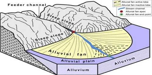 The alluvial fan & alluvial plain
Terai and Bhabar Region
Terai
1. Terai is a broad long zone south of Bhabar Plain.
2. It is a marshy damp area covered with thick forests.
3. It is 20-30 kms wide.
4. Many streams re-emerge here from the bhabar area
5. It is suitable for Agriculture. Terai and Bhabar regionBhabar
1. Bhabar is a long narrow plain along the foot hills.
2. It is a pebble studded zone of porous beds.
3. It is 8-16 kms wide.
4. Streams are lost in the region due to porous rocks.
5. It is unsuitable for Agriculture.
Bangar and Khadar Region
Bangar
1. The older alluvium of the plain is called Bangar.
2. This area stands above the level of the flood plain.
3. It is composed of calcareous kankars and clay.
4. The flood water does not reach here.
5. In some areas, local name Dhaia is given to this.
Khadar
1. The younger alluvium of the plain a called Khadar.
2. Flood water spreads a new layer over it every year.
3. It is composed of fertile alluvium.
4. These are actually flood plains of the rivers.
5. In some areas local new name Bet is given to this.
Antecedent drainage and consequent drainage
Antecedent Drainage
1. These rivers maintain their original slope (Before the uplift), despite the rise of the land due to folding. Rivers keep on flowing in the original direction.
2. These rivers are older than the fold mountains over which these rivers flow.
3. These rivers cut deep gorges due to down cutting.
4. The trans Himalayan rivers Indus, Sutlej, Kosi, represent antecedent rivers. Consequent and Antecedent drainage
Consequent Drainage
1. In an uplifted area, the rivers flow in the direction resulting as a consequence of the slope.
2. These rivers are formed after the uplift of the area.
3. These rivers do not form gorges.
4. The rivers of Peninsular India flow eastward, according to slope, and are consequent rivers.
Gorge and a Rift valley
A Gorge
1. A gorge is a narrow, deep valley with steep walls formed by river in hilly areas.
2. A gorge is formed by rapid down cutting of the river bed.
3. Indus gorge, Sutlej gorge are good examples found in India. Indus george
A Rift-valley
1. It is a trough formed by sinking of land between two faults.
2. It is formed due to the forces of tension.
3. Narmada valley and Tapti valleys are rift valleys in India. Narmada valleyImportant characteristics of the topographic complexities of the Himalayas
The Himalayas is a complex fold mountain system. The earth movements have formed many complex relief features such as:
(i) The Himalayas consist of a series of parallel mountain ranges. These ranges have been formed in different mountain building periods.
(ii) There are sharp and striking contrasts in altitude in the relief features. The curvature of the ranges, the hairpin bends, overthrust faults, suggest a complex topography found in the Himalayas.
Doab
Doab is a flood-plain formed in between two rivers. Doab separates two rivers but maintain a uniform character over the whole areas.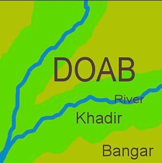 DoabFive Doabs in Punjab maintain a physical unity of the Punjab plains:
(i) Bist Jalandhar Doab — Between the Sutlej and the Beas.
(ii) Bari Doab — Between the beas and the Ravi.
(iii) Rachna Doab — Between the Ravi and the Chenab.
(iv) Chaj Doab — Between the Chenab and the Jhelum.
(v) Sind Sagar Doab — Between Jhelum-Chenab and the Indus Rivers.
Undulating plain in the Himalayas
Due to erosion some high undulating plains are found in the Himalayas. Some of these are—
(i) Aksaichin
(ii) Deosai
(iii) Depsang
(iv) Lingzi tang.
Dun
A dun is a narrow longitudinal valley in between two parallel mountain ranges. These are formed by the deposition of sediments. The important duns formed in the Himalayas are:
(i) Dehradun,
(ii) Kotli dun,
(iii) Patli dun
Continental shelf
Continental shelf is a broad shallow stretch of sea water descending on the ocean. It has a gentle slope and a depth of one hundred (100) fathoms. Continental shelf is formed by rise in the level of sea or a fall in the level of land. Continents really end at the edge of shelf.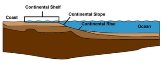 Continental shelfGeosyncline
Geosyncline is a long narrow trough in the earth’s crust. Due to the continuous deposition of the sediments the floor of the geosyncline keeps on sinking downward. These contain an enormous thickness of sediments. These sediments are folded to form mountains. It is often said that Fold mountains have risen out of “geosynclines.” GeosynclineHorst
A horst is an uplifted landmass between two parallel faults. The central mass sometimes keeps standing while the adjoining areas are thrown down. It takes the shape of a block mountain or a horst. The Vosges and Vindhyas are the examples of horst. HorstClassification of Indian rivers & the importance of river Basins
1. Major rivers are those having a catchment area of over 20,000 square km. These are large rivers in heavy rainfall areas.
2. Medium rivers have catchment areas between 2000 to 20,000 square km.
3. Minor rivers have catchment areas less than 2000 sq km.
There are 14 major river basins in India. The River basin is a separate hydrological unit and is useful for planning the utilisation of water resources for irrigation, power development, navigation and similar objectives. Their importance is only related to the harnessing of water resources.
They are not useful for other purposes as river basins have varying physiographic and climatic conditions and are not homogeneous regions. The exploitation of river water resources requires integrated planning and a degree of co-operation and understanding between the State concerned for sharing the burdens and benefits in an equitable manner.
Comments
Post a Comment